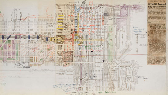
01. Congress Expressway map study, Cook County Highway Dept, c.1950.
The Congress Expressway, aligned on the "great avenue" that Burnham and Bennett conceived in the
Plan of Chicago, was the first superhighway linking Chicago's central business district to the
suburbs. Though $21 million was awarded the city for its construction in 1935, it took over 20
years for the first portion to be completed. Unlike earlier expressways, which were built largely
in low-density suburban areas, the Congress passed through some of the densest, oldest parts of
the inner city. In order to mitigate displacement, an existing railroad right-of-way was used for
part of the highway's path. This map, notated by architect J. Edwin Quinn, appears to be a study
of traffic flow in the Loop and a progress log of highway bridge construction for the Congress
Expressway.
"Chicago Looks Ahead: 100 Years of Planning, 1909-2009," Case 6, Ryerson & Burnham Libraries, September 29–December 1, 2010
Link to R&B Archives Digital Collections record